Well today I went on a brief trip to checkout the challenge Barcelona bike course.
The course starts in Calella and heads south west along the N-II to Mataro before heading North inland and climbing to Dosrius. The course turns around at Dosrius and heads back to the beach front along pretty much the same road. Once back to the coast, the route continues south west along the N-II to the turn around point at El Masnou. From El Masnou the route returns to Calella along the N-II.
The N-II road surface is pretty good for most of the way. There is a section approximately between Canet de Mar and Sant Pol de Mar where the surface is more bumpy with the road surface being more patch-work quilt like. The section of road between the N-II and the Dosrius turn around is not too bad either with only a few rough sections of road.
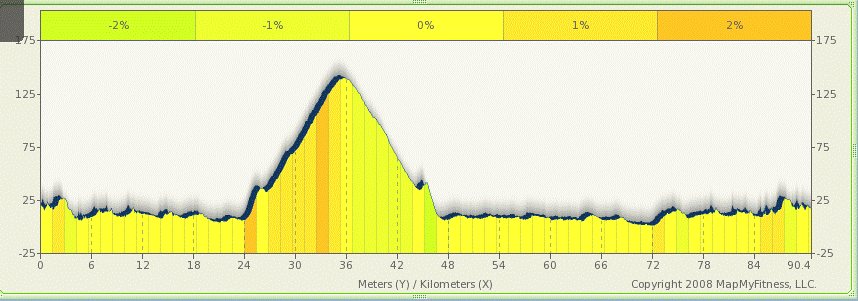
The N-II section south of around Canet de Mar is pretty much flat and runs along the beach front with a railway track between the beach and the road. There are certainly some false flats with subtle elevation changes of a couple of meters. North of Canet de Mar is slightly more undulating with a few climbs of 10-20m over a few hundred metres- meaning gradients of I guess roughly 2-4% for short sections. Nothing too taxing at all. Dosrius sits around 150m above sea level, based on my watch’s altimeter. There are some undulations in the climb to Dosrius, so the total ascent to Dosrius is probably closer to 200-250m. The climb to Dosrius is not too steep and did not seem to have any particularly large gradients – I’m guessing nothing more than 5-6%. Of course, going down a hill in a car makes is fairly difficult to accurately judge gradients.
I don’t recall the Dosrius loop being part of the original Challenge Barcelona route which would otherwise be very flat. The N-II section of the course is fairly boring: sea and railway track on one side and buildings on the other – no real scenery to appreciate apart from the first/last few kilometres around Calella.
I will try and find some accurate gradients and elevations for various points along the route and will update this post if I find any.
I have added a route to mapmyride.com for this course and is available at http://preview.tinyurl.com/chalbarc
A graph of the profile, from the MapMyRide site is shown below:

Leave a Reply to Tracy Cancel reply